Happy Canada Day!
Happy Canada Day! On July 1, 1867, New Brunswick, Nova Scotia, and the Province of Canada were proclaimed the Dominion of Canada, to be led by Prime Minister Sir John A. Macdonald (1815-1891). With the Province of Canada now divided into Ontario and Quebec, Canadian Confederation effectively brought together four provinces; the young nation would continue to grow and reorganize, mostly in the nineteenth century but continuing to the end of the twentieth century as well, the last territory added being Nunavut, which was carved out of the Northwest Territories on April 1, 1999.
Of course, the history of the First Nations of the landmass known as Canada is vast and varied, and long predates European colonization. Canada Day is thus the result of a specifically European project that changed the course of the lands now known as the Americas. On this anniversary, we present one moment in the early stages of that project, focusing specifically on Venetians’ cartographical reckoning with the “New World” as a potential new route to the lucrative trading posts of Asia.
Earlier this year, we presented the widely influential maps of Giacomo Gastaldi (ca. 1500-1566), included in the first Italian vernacular translation of Ptolemy’s Geographia, which appeared in Venice in 1548 (see the complete description of this copy here, and the blog post “Updating Ptolemy” here). The Geografia of 1548 represents a groundbreaking publishing initiative in many regards. Aimed at disseminating geographical knowledge to a broader reading public, it was the first ‘atlas’ ever printed in the octavo format, and thus significantly departed from the earlier tradition of Ptolemy editions written in Latin, issued in large format, and addressed to a more scholarly audience.
Claudius Ptolemaeus (ca. 100-168) - Giacomo Gastaldi (ca. 1500-1566), Ptolemeo. La geografia di Claudio Ptolemeo alessandrino, con alcuni comenti et aggiunte fattevi da Sebastiano Munstero Alamanno, con le tavole non solamente antiche et moderne solite di stamparsi, ma altre nuove aggiuntevi di messer Iacopo Gastaldo piamontese cosmographo, ridotta in volgare italiano da m. Pietro Andrea Mattiolo [...], Venice, Niccolò Bascarini for Giovanni Battista Pederzano, October 1547.
As defined by Nordenskiöld, this edition also represents “the very first atlas of the New World.” Of the 31 maps included in the edition, five were dedicated to the New World: the Tierra Nova (South America), Nueva Hispania Tabula Nova, Tierra Nueva (Eastern North America), and separate maps of Cuba and Hispaniola (now the Dominican Republic), bearing the titles Isola Cuba Nova and Isola Spagnola Nova, respectively. These are the earliest regional maps of America ever printed.
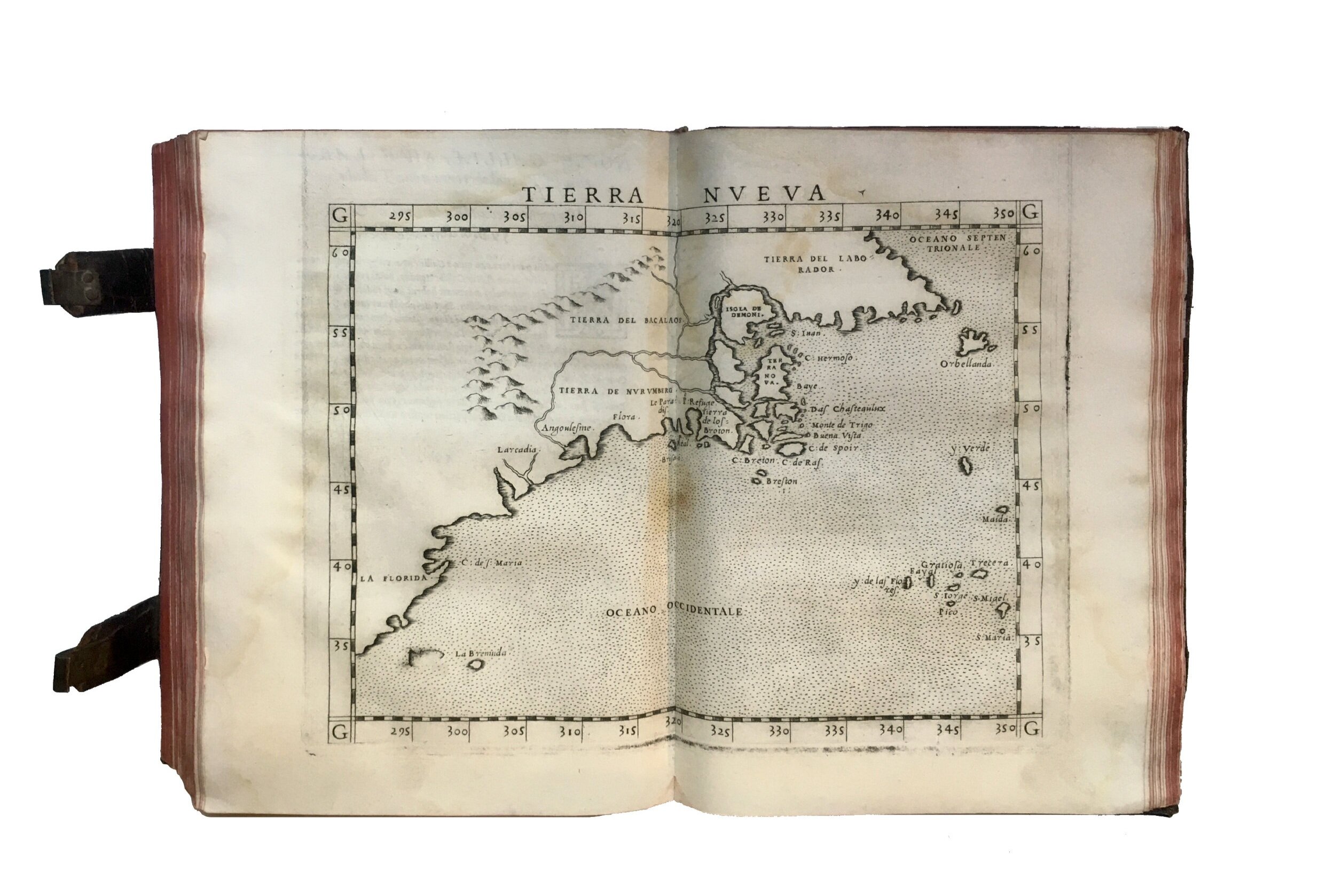
The Tierra Nueva map, showing the Atlantic coast of North America from Labrodor to Florida, is also probably the first map to record the travels of the French navigator Jacques Cartier (1491-1557) to the Gulf of Saint Lawrence between 1534 and 1542.
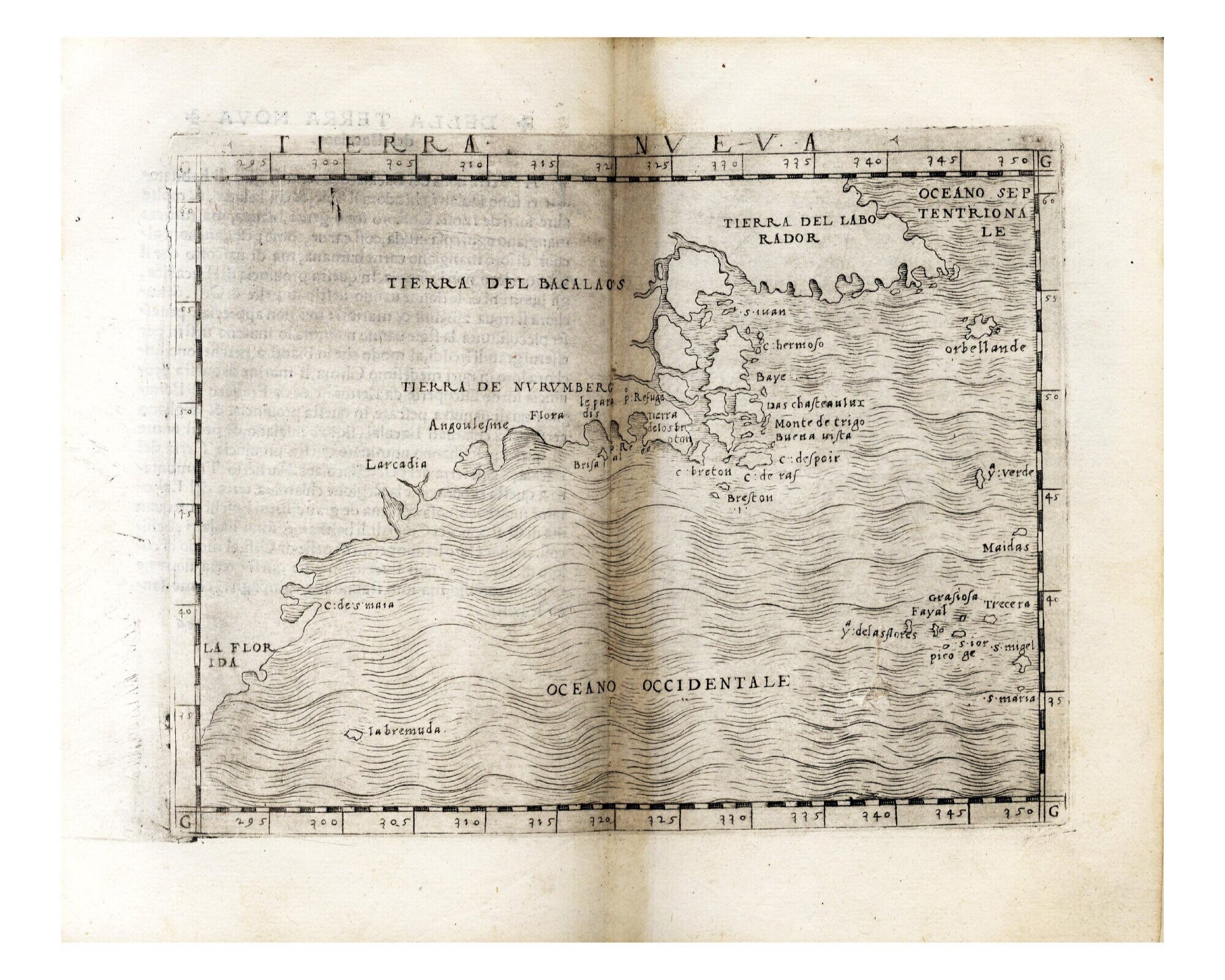
Tierra Nueva map by Giacomo Gastaldi (ca. 1500-1566), from Claudius Ptolemaeus (ca. 100-168) - Giacomo Gastaldi (ca. 1500-1566), Ptolemeo. La geografia di Claudio Ptolemeo alessandrino, con alcuni comenti et aggiunte fattevi da Sebastiano Munstero Alamanno, con le tavole non solamente antiche et moderne solite di stamparsi, ma altre nuove aggiuntevi di messer Iacopo Gastaldo piamontese cosmographo, ridotta in volgare italiano da m. Pietro Andrea Mattiolo [...], Venice, Niccolò Bascarini for Giovanni Battista Pederzano, October 1547.
The map also contains the first mention in printed cartography of the ‘Tierra de Nuremberg’ (Norumberga, or Noruberga), a designation used by cartographers from 1548 until 1614, when Captain John Smith renamed the region New England. The ‘Tierra de Nuremberg’ (the etymology of which is still debated) was first noticed by the Italian explorer Giovanni da Verrazzano (1485-1528) during his 1524 voyage to the New World on behalf of Francis I, King of France. What’s more, Gastaldi’s coastline includes the mention of the harbor ‘Angoulesme’, the first European name for New York Bay, so named by Verrazzano in honour of the French King, known before his ascent to the throne as the Count of Angoulême.
Among the landmasses articulated in Gastaldi’s map is a large island off the coast of Tierra del Labrador (roughly northern Newfoundland). In his 1556 map of La Nuova Francia, Gastaldi clearly names this island ‘Isola de Demoni’, i.e., Island of Demons. This map was created for the third edition of Delle navigationi et viaggi by Gastaldi’s friend Giovanni Batista Ramusio (1485-1557), a geographer, diplomat, and secretary of the Venetian Senate.
A legendary island filled with monsters and demons, the ‘Isola de Demoni’ was relayed in a story, recounted by Jacques Cartier, about aboriginals “dressing as devils to discourage Cartier and his men from proceeding to visit the native settlement of Hochelaga” (fol. 444r, chapter 4 of Cartier’s Secunda Relatione, cited in “Giacomo Gastaldi, La nuova Francia, 1556” in C. V. Duzer and L. Beck, eds. Canada Before Confederation, Vernon Press, 2018, p. 69).
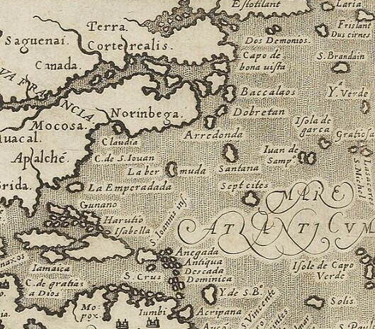
The island reappears in a map of the same region by Girolamo Ruscelli (1518-1566). Ruscelli based his map on Gastaldi’s, and it was first used for his new Italian translation of the Geographia printed by the Venetian printer Vincenzo Valgrisi in 1561 (it was thereafter frequently reprinted until 1598). Ruscelli’s is therefore the second earliest map to focus on the east coast of North America. We present it here as included the Latin Ptolemy of 1562, edited by the mathematician Giuseppe Moleti (1531-1588) and issued in folio size, likewise from the Valgrisi press (see the full description of our available copy here).
Girolamo Ruscelli’s “Tierra Nueva” map in Claudius Ptolemaeus (ca. 100-168) - Giuseppe Moleto (1531-1588), Geographia Cl. Ptolemaei Alexandrini Olim a Bilibaldo Pirckheimherio traslata, at nunc multis codicibus graecis collata, pluribusque in locis ad pristinam ueritatem redacta a Iosepho Moletio mathematico, Venice, Valgrisi Vincenzo, 1562.
The name is, however, attributed to various sources. In his L’uniuersale fabrica del mondo, for example, a work likewise influenced by Gastaldi, Gianni Lorenzo da Anania (1545-1609) wrote that the demonic toponym came from a French tale of a woman named Margarita. An adulteress, Margarita was abandoned on the island and sailors passing by could hear her moans.
Anania’s L’uniuersale fabrica, which first appeared in Naples in 1573, was well received, and two editions followed in Venice in the sixteenth century, in 1576 and 1582, respectively. We present here the Venetian edition of 1582, in an exceptional copy once preserved in the celebrated library assembled by the Pillone family over several generations in their Villa of Casteldarno in Val Cadore, near Belluno (for a complete description click here). The volume includes an engraved map titled “Orbis Descriptio” along with four engraved maps of the continents known at the time: Europe, Asia, Africa, and the Americas.
Detail of Anania’s “America” map from his L’uniuersale fabrica del mondo, overo Cosmografia... Diuisa in quattro Trattati... Di nuouo ornata con le figure delle quattro parti del Mondo in Rame. Venice, Andrea Muschio for Giacomo Aniello De Maria, 1582.
This “Pillone” volume is housed in a magnificent vellum binding decorated with India ink and wash drawings by Cesare Vecellio (1521-1601), a cousin and pupil of Titian. The Pillone Library was large and varied, and well supplied with geographical books and travel narratives. The present copy of Anania’s Universale fabrica del mondo or Cosmografia is one of only twenty-one volumes bound in vellum whose covers were finely decorated by Vecellio with drawings appropriate to the content of the book: on the upper cover, the artist depicts a map of Europe, Asia, and Africa, while the lower cover bears a map depicting the Mondo Novo.

Decorated lower cover by Cesare Vecellio (1521-1601), with map of the New World (Mondo Novo). Gianni Lorenzo da Anania (1545-1609), L’uniuersale fabrica del mondo, overo Cosmografia... Diuisa in quattro Trattati... Di nuouo ornata con le figure delle quattro parti del Mondo in Rame, Venice, Andrea Muschio for Giacomo Aniello De Maria, 1582.
As the lower cover indicates, North America was, at the time, thought to be contiguous with Asia. Although a few maps depicted the two lands distinct from one another, for the vast majority of cartographers in the sixteenth century, the latter was generally thought to be an extension of the former. (E. Horodowich, The Venetian Discovery of America, Cambridge University Press, 2018, p. 127)
This is also how Gastaldi presented North America in the two world maps included in the 1548 Geografia: the “Universale Novo”, which is a reduced version of Gastaldi’s first world map published separately in 1546, and the navigational chart “Carta Marina Nova Tabula”, which clearly represents Asia and America as a single continent, connected to Northern Europe through Greenland.
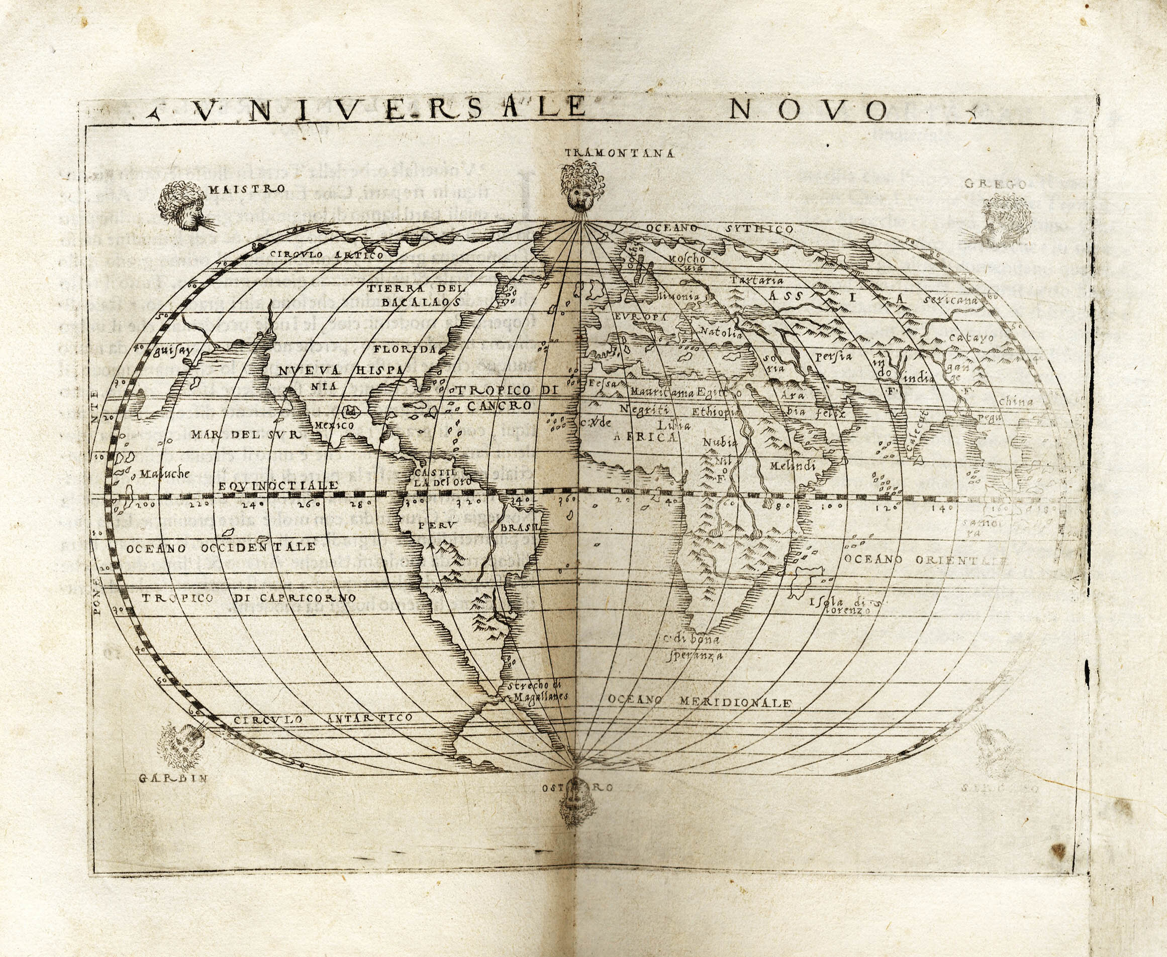
Universale Novo map by Giacomo Gastaldi (ca. 1500-1566), from Claudius Ptolemaeus (ca. 100-168) - Giacomo Gastaldi (ca. 1500-1566), Ptolemeo. La geografia di Claudio Ptolemeo alessandrino, con alcuni comenti et aggiunte fattevi da Sebastiano Munstero Alamanno, con le tavole non solamente antiche et moderne solite di stamparsi, ma altre nuove aggiuntevi di messer Iacopo Gastaldo piamontese cosmographo, ridotta in volgare italiano da m. Pietro Andrea Mattiolo [...], Venice, Niccolò Bascarini for Giovanni Battista Pederzano, October 1547.
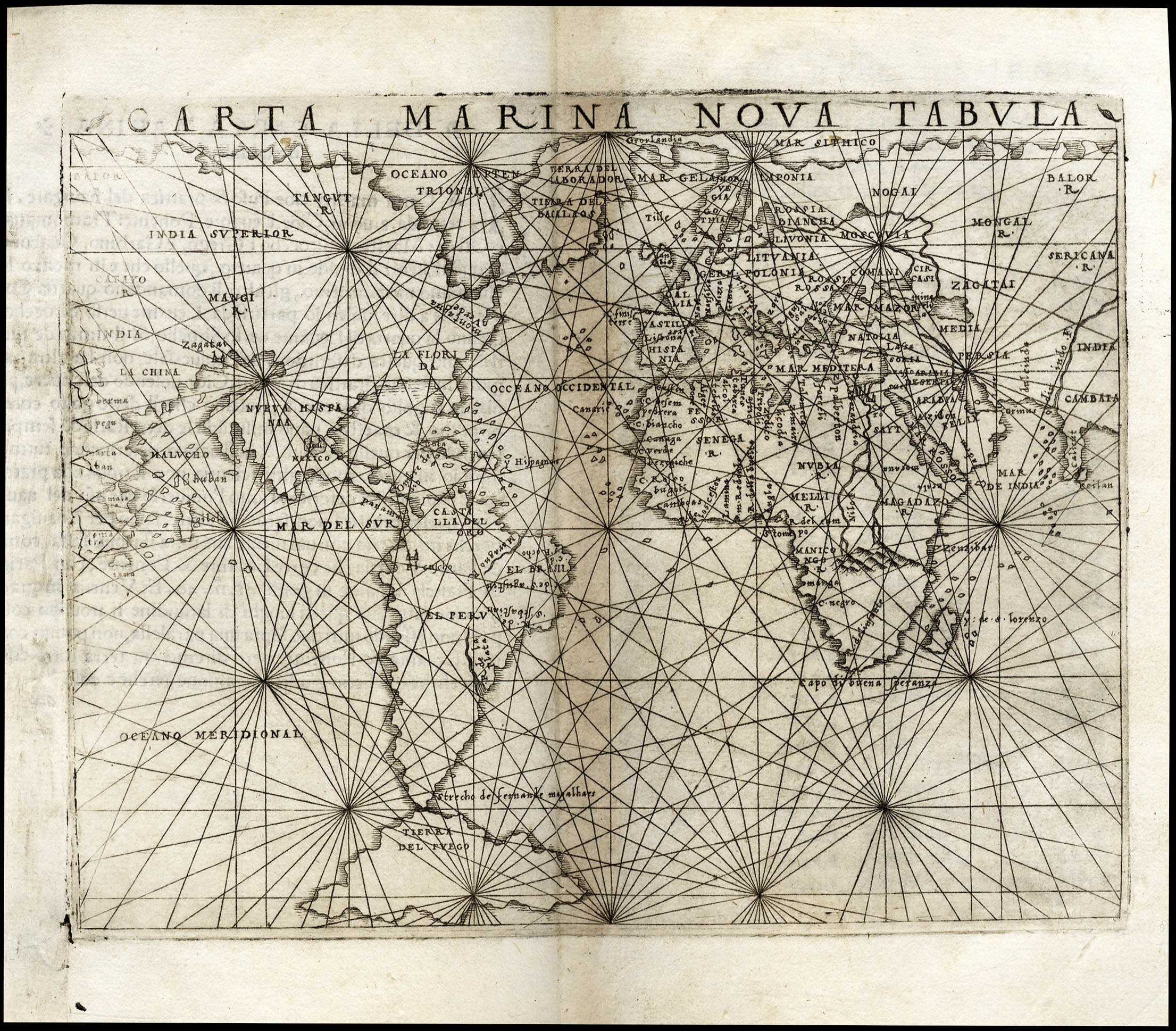
Arta Marina Nova Tabula map by Giacomo Gastaldi (ca. 1500-1566), from Claudius Ptolemaeus (ca. 100-168) - Giacomo Gastaldi (ca. 1500-1566), Ptolemeo. La geografia di Claudio Ptolemeo alessandrino, con alcuni comenti et aggiunte fattevi da Sebastiano Munstero Alamanno, con le tavole non solamente antiche et moderne solite di stamparsi, ma altre nuove aggiuntevi di messer Iacopo Gastaldo piamontese cosmographo, ridotta in volgare italiano da m. Pietro Andrea Mattiolo [...], Venice, Niccolò Bascarini for Giovanni Battista Pederzano, October 1547.
It is also this version of Canada as being the eastern extremity of Asia that Gastaldi would have painted on the walls of the Doge’s Palace in 1553, although sadly this map no longer survives.
That the Doge wanted Gastaldi’s maps painted in his palace is a testament to the importance of exploration and Venice’s place in the world. As of the 1530s, the lagunar town had become an important centre for cartography and the map trade, owing to its broad commercial relationships and the presence of wealthy merchants who were deeply interested in learning about the maritime world and the possibilities of new shipping routes. This demand had favored the birth, in Venice, of workshops specialized in the production of nautical charts, coastal views, topographies, and maps of European countries and the New World. Numerous cartographers therefore came to choose Venice as a privileged place for remunerative activity.
But the Republic had also long been a dominating force in the Mediterranean as well as in European trade with the Middle East and much of the rest of Asia. It was in this context that the Venetian Marco Polo (1254-1324) set out on his 24-year journey into central Asia, the account of which was then published as The Travels of Marco Polo.
By the end of the fifteenth century, the possibility of an alternative route to Asia motivated much European exploration of the New World. Indeed, it was in search of a way through the continent that Cartier had explored the Saint Lawrence River in 1535. Earlier still, the first recorded attempt at the discovery of a Northwest Passage was performed by the Italian explorer Giovanni Caboto (John Cabot), who, though born in Genoa, had moved to Venice around 1461 where he likely worked as a merchant in the spice trade. In 1497, Caboto set sail on the first of his two expeditions, on a voyage commissioned by Henry VII. At that time, he made landfall likely in Newfoundland, Cape Breton Island or southern Labrador. He departed for a second expedition in 1498 but is thought to have died in a shipwreck along the way.

Mosaic of Marco Polo, Municipal Palace of Genoa: Palazzo Grimaldi Doria-Tursi.
In 1561, Gastaldi published a pamphlet stating that North America was in fact separated from Asia by a body of water called the Strait of Anian (the pamphlet accompanied a map called Cosmographia universalis et exactissima iuxta postremam neotericorum traditio[n]em, which survives in a unique copy held at the British Library, Maps C.18.n.1). The name of this strait likely derives from Marco Polo’s use of the name “Ania” for a Chinese province mentioned in the new critical edition of Polo’s Travels by Gastaldi’s friend Ramusio wich appeared in 1559.
In the section called “On the Gulf of Cheinan,” Ramusio includes a description by Polo about a large gulf that existed in northeastern China.
Leaving the port of Zaitum (modern Quanzhou), one sails westward and a bit southwest for 1500 miles, passing through a gulf named Cheinan (roughly the modern South China Sea) which takes two months to travel across, navigating towards the north. The entire gulf is bounded on the southeast side by the province of Manzi and on the other side by Ania and Toloman, besides many other provinces ... This gulf is very large, and so many people live there that it seems almost (like) another world.
(Polo, volume 2, book 3, chapter 5, in Ramusio, Navigazioni e viaggi, 3:256, translated by Horodowich, The Venetian Discovery of America, p. 130).
Largely absent from other editions of Polo’s Travels, the passage presented Gastaldi with a new conception of the relationship between Asia and America.
Looking to the south along the Chinese coast, Ramusio’s Polo describes the mainland province of Manzi ahead of him to his right, and Anian and Tholman distantly behind him to his left, or otherwise, in the northwest corner of the American continent, just as Gastaldi’s maps illustrate. Ramusio encouraged Gastaldi to understand that Anian was “on the other side” of this large gulf, in “another world” or in other words, potentially, in a New World, in America.” (Horodowich, The Venetian Discovery of America, p. 130)
Looking to “the other side,” Gastaldi also positioned the Asian provinces of Tolman and Aagama in the northwest of North America. Pegu, the capital of Burma, likewise made its way over to the Americas. Indeed, the distinction between America and Asia remained cloudy at best, and in his Cosmographia universalis (Venice, c. 1561), Gastaldi presents Tartars (Mongols) riding on camels into what is now Canada, where Elephants are also seen to roam around. “That is to say, these Venetian cartographers illustrated Asian fauna and toponyms in what is today Canada.” (Horodowich, The Venetian Discovery of America, p. 131)
Notably, along with the first inclusion of the Strait of Anian, Gastaldi’s Cosmographia universalis of 1561 also shows one of the earliest uses of the name “Canada” on a European map. As a name, “Canada” is thought to have derived from “kanata,” the Huron-Iroquois word for “village” or “settlement.” Although it wasn’t used in an official context until 1791, with the division of the Province of Quebec into the colonies of Upper Canada and Lower Canada, Cartier had used it as early 1535 in reference to the native village and territory of Stadacona, in the region of what is now the City of Quebec. Maps dating back to the 1540s refer to the lands north of the St. Lawrence River as Canada, and Cartier’s reference to that same river as “Rivière du Canada” remained in use until the early seventeenth century. Thus by 1616, even if the region was officially named New France, Europeans knew the area as Canada.
By the time the colonies of Upper and Lower Canada were consolidated in 1841 to form the Province of Canada, several names for the new confederation had been proposed, including Hochelaga, an old name for Montreal; Mesopelagia, meaning 'land between the seas'; Tupona, an acronym derived from The United Provinces of North America; and Efisga, a name made up of the first letters of England, France, Ireland, Scotland, Germany and Aboriginal.
How to cite this information
Julia Stimac, “Happy Canada Day!” PRPH Books, 1 July 2020, https://www.prphbooks.com/blog/canada-day. Accessed [date].This post is licensed under CC BY-SA 4.0.